AU20 MMS
High-End Mobile Mapping System
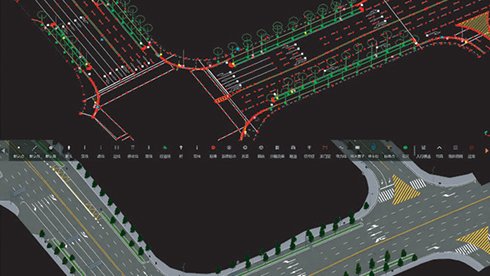
The CHCNAV AU20 MMS is a high-precision mobile mapping system designed for vehicle-mounted applications. Its advanced LiDAR and AI-powered algorithms capture accurate 3D spatial data while streamlining field-to-office workflows. The system supports flexible sensor configurations for a wide range of applications from road surveying and infrastructure management to reconstruction and as-built verification.
-
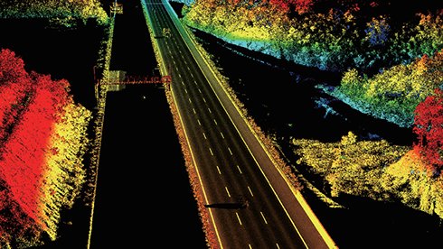
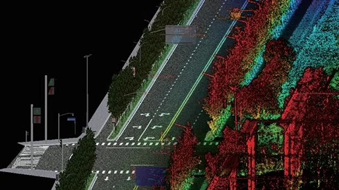
Long-range LiDAR scanning of up to 1450 m, along with extremely high-speed scanning of 2 million points per second and scanspeeds of up to 200 scans per second
Extremely high quality point cloud with low range noise
Strong vegetation penetration, up to 16 target echoes, ability to easily generate real DEM, DSM in challenging conditions
Various imaging systems to support different platform setups, including full-frame camera for high-accuracy UAV LiDAR+Imaging
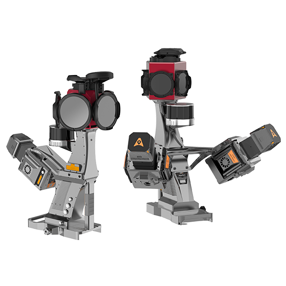
AlphaPano vehicle installation platform, which include panoramic camera and SLAM scanner integration for optimized position in GNSS challenging environment
Simple setup on various platforms, including crewed aircrafts, drones, vehicles, marine vessels, and even backpack
All-in-one processing software, including strip adjustment and orthomosaic, as standard features
Main Features
-

High-Precision
2M points/sec with 5 mm accuracy and 3 mm precision.
-
High-Density
2M points/sec within a 250 m range, 4× higher point density.
-

Multi-Sensor Design
Single/dual laser, pavement sensor, Ladybug5+/6 panoramic cameras.
-

AI-Powered
>95% panoramic coloring accuracy and point cloud errors within 2 cm.
Precise Data Capture
Powered by 4th Gen Real-time Waveform Processing (RWP) technology, the AU20 MMS captures up to 2 million points per second at 200 revolutions per second. Delivering 5 mm accuracy and 3 mm precision, it effectively captures road textures, manhole covers, and fine markings with survey-grade detail.
High-Density Point Cloud
The AU20 leverages long-range, multi-cycle LiDAR to generate point clouds with 4× greater density within a 250-meter range. This enables exceptional clarity for complex roadside structures and pavement surfaces.
Dual-Laser Scanning
The AP7 platform supports a dual-laser configuration, doubling point density and coverage. Its 45° scanning angle enables simultaneous, multi-angle data capture, reducing blind spots, enhancing road sign detection, and improving feature recognition under dynamic conditions.
Multi-Sensor Integration
The AP7’s built-in processor supports up to 8 external sensors, including pavement cameras, enabling comprehensive road damage detection. Seamless compatibility with Ladybug5+ and Ladybug6 panoramic cameras offers unmatched operational flexibility for diverse mapping scenarios.
AI-Enhanced Colorization
Using advanced AI, the AU20 delivers >95% panoramic coloring accuracy by detecting and filtering vehicles, pedestrians, and environmental noise. One-click optimization produces clean, interference-free point clouds for high-fidelity mapping.
Automated VMA Correction
Built-in AI algorithms automatically detect and correct vertical mapping alignment (VMA) errors using control points, maintaining <2 cm accuracy. This ensures compliance with highway-grade standards even in complex environments.

Specifications

Laser Scanner
Range: 1.5~250 m (vehicle-mounted) 1.5~1450 m (airborne)
Scanning Rate: 2,000,000 pulses/sec
Field of view: 360°
Returns: Up to 16
Positioning
IMU: 600 Hz