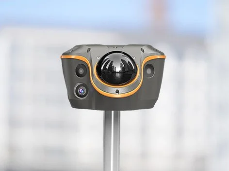
ViLi i100
Visual-LiDAR GNSS RTK Receiver with Consistent Accuracy in Obstruction
Flagship GNSS RTK receiver, combining advanced satellite filtering, enhanced SFix 2.0 positioning and innovative Vi-LiDAR technology.
-
Integrated Visual-LiDAR and multi-constellation GNSS enable contactless surveying and real-time 3D point capture, extracting multiple points from a single image without aiming or pole stability.
SFix 2.0 delivers reliable ±5 cm accuracy within 20 m in GNSS-denied areas, maintaining consistent positioning in obstructed environments.
1408-channel GNSS with iStar 2.0 and a 200 Hz calibration-free AUTO-IMU provides stable tilt-compensated measurements up to 60°.
Survey-grade performance with RTK accuracy of 8 mm + 1 ppm horizontal and 15 mm + 1 ppm vertical, PPK accuracy of 3 mm + 1 ppm horizontal and 5 mm + 1 ppm vertical, and high-precision static accuracy down to 2.5 mm + 0.1 ppm.
All-in-one flagship receiver supporting RTK (UHF and NTRIP), PPP, PPK, static, SFix, and Vi-LiDAR workflows, eliminating the need for total station switching.
Real-time 3D point cloud earthwork and volume calculations enable fast, safe, and non-contact cut and fill measurements directly on site.
Rugged IP67 and IK08 design for harsh field conditions, operating from −20°C to +55°C, with up to 22 hours of RTK rover operation or approximately 5 hours of LiDAR scanning.
Main Features
-

Confident and Consistent Accuracy in Obstruction
5 cm accuracy, even in challenging GNSS environments. Once right, always right.
-

Enhanced SFix 2.0 Engine
5 cm accuracy within 20 m in GNSS-denied Areas.
-

3D Point Cloud Earthwork Calculation
Simply scan, define the boundary, and get instant results with 99.98% accuracy.
-

Vi-LiDAR Contactless Survey
Capture a photo once and extract survey points in batches.
Confident Accuracy in Obstructed Areas
Powered by next-gen sensor fusion and 3D laser scanning, the ViLi i100 redefines accuracy and reliability. It filters GNSS satellite signals affected by blockage or reflection, ensuring stable, jump-free 5 cm accuracy in challenging environments such as alleys, forests, or near high-rise buildings. Once right, always right.
Enhanced SFix 2.0 Engine
With its SFix 2.0 engine, ViLi i100 delivers 5 cm accuracy within 20 meters in GNSS-denied areas by using 860,000 pts/sec LiDAR and SLAM-based constraints. Trained on tens of thousands of real-world datasets, it resolves GNSS outages without the need to switch to a total station.
3D Point Cloud Earthwork Calculation
With high-precision laser sensing and LandStar software, ViLi i100 enables real-time cut and fill volume calculations on site with 99.98% accuracy. Simply scan, set boundaries, and receive instant results. No surface contact is required, making the workflow accurate, efficient and safe.
Fast Contactless Capture with Vi-LiDAR
With Vi-LiDAR, capture a scene once and batch-select target points to extract multiple 3D coordinates without the need to aim precisely or stay steady. The ViLi i100 eliminates the impact of hand tremors, increases speed and safety, and delivers 5 cm accuracy even at 15 meters with its 8 MP telephoto camera.
All-in-One GNSS Receiver for Any Workflow
ViLi i100 is an all-in-one GNSS receiver combining standard RTK features with next-gen innovation. Paired with LandStar software, it supports CORS, UHF, and PPP modes. Dual cameras enable CAD and AR visual stakeout, increasing efficiency by 50%. The ViLi i100 is reliable and built for professionals.